For more information regarding the value of a property, please contact us for a free consultation.
Key Details
Sold Price $2,250,000
Property Type Vacant Land
Listing Status Sold
Purchase Type For Sale
MLS Listing ID 23-4030
Sold Date 02/14/24
Originating Board Alaska Multiple Listing Service
Lot Size 1685.802 Acres
Acres 1685.0
Property Description
Once in a lifetime opportunity to own nearly 1700 acres of pristine wilderness with over 10 miles of Nome River frontage. The property consists of 15 federally patented mining claims with surface, subsurface estate and mineral rights. Located in the unorganized borough and close to the Seward Peninsula hub city of Nome. There are no property taxes for this land. Accessed by the Nome-Taylor Highway (NTH), a gravel year round state maintained road. Various access points throughout the property. Electric and phone is available along the NTH up to the Banner Creek Subdivision.
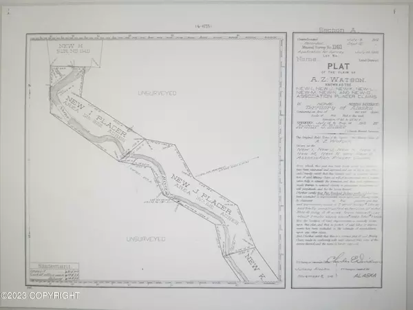
This listing consists of two US Mineral Surveys: The remaining portion of USMS 1140 including the following Association Placer Mining Claims: Portion "New A," portion "New B," "New C," portion "New D," "New E," "New F," "New G," and portion "New H," and USMS 1161 includes the following placer mining claims: New I, New J, New K, New L, New M, New N, and New O.
USMS 1140 claims were located on July 3, 1912 and this mineral survey was approved November 25, 1914. USMS 1161 claims were located on July 9, 1912 and this mineral survey was approved November 8, 1915.
Acreage is approximate and was calculated from the US Mineral Surveys and extracting the following subdivisions: Banner Creek, Banner Creek 1st Addition, Banner Creek 2nd Addition, Granny's Camp and Dexter Townsite, as well as other exceptions as noted in the preliminary commitment for title insurance.
For GIS information including but not limited to GPS coordinates, contour and aerial imagery go to: https://sdms.ak.blm.gov/acres/acres_menu > Map Interface > pan to Nome and zoom in along Nome-Taylor Hwy approximately 3 + miles north of where the Nome River empties into the Norton Sound. The southern end of USMS 1161 is located in the SW corner of section 26 > activate the following layers: Federal Mining Claims and MTPs. To change the base map, use the the 4 square icon in the upper bar to access the base map gallery. In the bottom left hand corner GPS coordinate are available for any position the arrow is placed on the map.
For wetlands information, click on the following link for the US Fish and Wildlife Service "National Wetlands Inventory": https://www.fws.gov/program/national-wetlands-inventory/wetlands-mapper > Launch Wetlands Mapper at bottom of page > Zoom in to Nome area. This GIS system does not outline private parcel boundaries.
This entire area is unmapped by FEMA for flood zone data.
General partner is licensed real estate broker in State of Alaska.
Location
State AK
Area 835 - Nome Census Area-All
Zoning UNZ - Not Zoned
Direction From downtown Nome, East on Front St becomes Nome-Council Rd, Left on Nome-Taylor Highway (aka Beam Road) to Property. Call for more information.
Exterior
Waterfront Description River
Building
Lot Size Range 1685.0
Schools
Elementary Schools Nome
Middle Schools Nome-Beltz
High Schools Nome-Beltz
Read Less Info
Want to know what your home might be worth? Contact us for a FREE valuation!

Our team is ready to help you sell your home for the highest possible price ASAP

Copyright 2025 Alaska Multiple Listing Service, Inc. All rights reserved
Bought with Russo Realty

